Where to Get a Site Plan for a Permit Application
Where to get a site plan for a permit application: six sources compared on cost and speed, plus what the drawing has to show.
You can get a site plan for a permit application from six places: your own closing documents, your county's GIS map, an online drafting service, a local drafter or architect, a licensed surveyor, or a GIS-based service like Ergeon's site plan, which delivers a permit-ready PDF in about 15 minutes for $29. Which one is right depends on two things: whether your permit office requires a certified drawing (most residential fence, deck, shed, and pool permits do not) and how fast you need it. This guide compares the six sources on cost, speed, and what you get, lists what the drawing has to show so it is not sent back, and explains the one situation where only a surveyor will do.
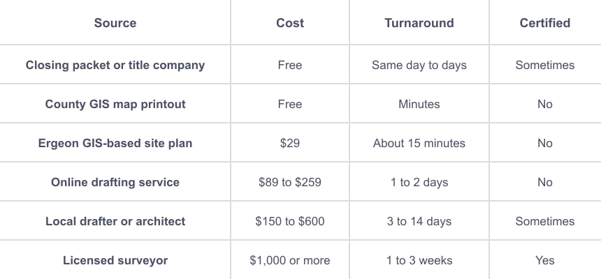
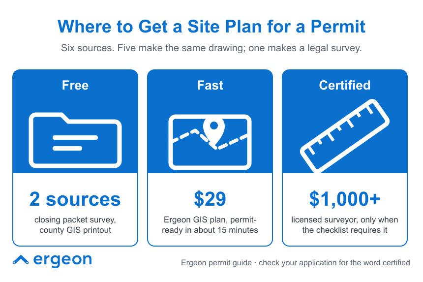
The first thing to notice is that five of the six produce the same category of document: a scaled drawing of your lot from records, which is what most residential permit checklists mean by "site plan" or "plot plan." Only the surveyor produces a legal boundary determination, and only a checklist that says "certified," "stamped," or "sealed" requires it. Ergeon's guide to site plan vs. survey vs. plot plan explains the difference.
Start here because it is free. Many home purchases include a survey or plat in the closing packet, and your title company or lender may have a copy on file if you do not. An older survey will not show your proposed project, but it gives you accurate lot lines and the house footprint to trace from, and some permit offices accept a survey with your project sketched on it. Ergeon's guide on how to get a copy of your property survey lists exactly where to look.
The catch: a survey from 2004 may not reflect a neighbor's addition, a lot-line adjustment, or your own new patio, and many are scanned at a quality that is hard to draw on cleanly.
Every county publishes a parcel map online, and most let you print a parcel outline with dimensions. Many cities accept a hand-drawn, to-scale site plan on that printout for simple residential lots. It costs nothing but your time.
The catches are the same ones that make this the most common source of resubmittals: the printout may be grainy or unscaled, the building footprint is often approximate, and you are responsible for drawing setbacks, the north arrow, and the project accurately. If the reviewer cannot measure it, it comes back.
Ergeon's site plan automates what you would otherwise do on the GIS printout, with cleaner data. Enter your address, pay $29, and in about 15 minutes you get a permit-ready PDF at 11 by 17 showing property lines and lot dimensions from county parcel records, the building footprint from verified aerial data, measured setback distances, adjacent parcels, scale, and a north arrow. No account is needed, one free revision is included if your permit office sends it back, and if it cannot be made right, the order is refunded.
For a fence, the Project Planner tier adds a proposed fence layout you can print, mark up, and turn into a free Ergeon quote. It is the same GIS site plan Ergeon uses as the base for its own permit filings, with your fence layout and any other documents the city requires added on top. The caveat applies here as to every records-based plan: parcel data is a starting canvas, not a legal boundary determination.
Several national services draft non-certified site plans from county records and your project description, typically $89 to $259 with one to two day turnaround and corrections included if the city comments. They are a reasonable fit when your project is more complex than a fence (an ADU or addition, for example) and you want a human drafter formatting the sheet to a specific checklist.
A local drafter produces a scaled plan from records and your sketch for roughly $150 to $400, and an architect's office for more, usually as part of a larger set of drawings for an addition or new construction. Turnaround runs several days to two weeks. For a fence, shed, or deck this is more than the permit needs; for a project with structural or elevation requirements it is the right call.
A surveyor is the only source that can produce a certified site plan, because it is the only one who legally establishes where your boundary sits. Fieldwork, deed research, corner monuments, and a stamp come with it, which is why it costs $1,000 or more and takes one to three weeks. Order it when the permit checklist says certified, stamped, or sealed; when a variance or zero-lot-line construction is involved; or when the boundary itself is disputed. Ergeon's guide to property line survey cost covers what drives that price.
Whichever source you use, the reviewer is checking for the same elements. Missing any one of them is the usual reason a permit application stalls:
Some offices add impervious surface totals for patios, corner sight triangles for driveways, or tree locations under a tree ordinance. The application for your project type lists the exact set. For a fence specifically, Ergeon's guide to whether you need a site plan for a fence permit walks through each item.
The expensive mistake is starting with a surveyor because that is the only professional that comes to mind, and assuming a $1,500 quote with a three-week wait is what a site plan costs. For most residential permits it is not. Ergeon's guide to how much a site plan costs lays out the tiers.
If your fence needs a permit, Ergeon's project manager handles the application after you approve the quote, using the same GIS site plan as the base with your fence layout added. The quote itself happens without a sales visit: you draw the fence line on a satellite map for an instant estimate, a specialist confirms slope, gates, access, and removal on a live video call, and the itemized price comes from a CAD model that carries real materials, quantities, labor, and live pricing. Ergeon is licensed, bonded, and insured in every market it serves, holds a 4.81 out of 5 rating across more than 22,000 verified reviews, and typically schedules builds within about 20 days of approval. See how it works or call 1-888-374-3661.
Where can I get a site plan for a permit?
From your closing packet or title company (free, if a prior survey exists), your county GIS map (free printout you draw on), Ergeon's GIS-based site plan ($29, about 15 minutes), an online drafting service ($89 to $259, one to two days), a local drafter or architect ($150 to $600 or more), or a licensed surveyor ($1,000 or more, one to three weeks).
Can I draw my own site plan for a permit?
Often, yes. Many cities accept a hand-drawn, to-scale plan on a county GIS printout for simple residential lots. It is also the most common reason for a resubmittal, and any property-line error is your responsibility.
Does a site plan for a permit have to come from a surveyor?
Only when the checklist says certified, stamped, or sealed, or when the boundary is disputed. Most fence, deck, shed, and pool permits accept a scaled drawing from county records.
How fast can I get a site plan?
Minutes, if you print the county GIS map or order Ergeon's $29 plan, which arrives in about 15 minutes. Drafting services take one to two days, local drafters several days to two weeks, and surveyors one to three weeks.
Will Ergeon's $29 site plan be accepted by my permit office?
It includes the elements permit offices ask for: property lines, building footprint, setbacks, scale, and north arrow, drawn from county parcel records and verified building footprints. If your office rejects it, one revision is free, and if it cannot be made right, the order is refunded.
Get a free fence quote - Call 1-888-374-3661. Monthly-payment financing is available on qualifying projects.
 Local Guides
 Local Guides
 Local Guides


