Site Plan vs. Survey vs. Plot Plan: What Is the Difference?
Site plan vs survey vs plot plan: what each one shows, who makes it, what each costs, and which one your permit office wants.
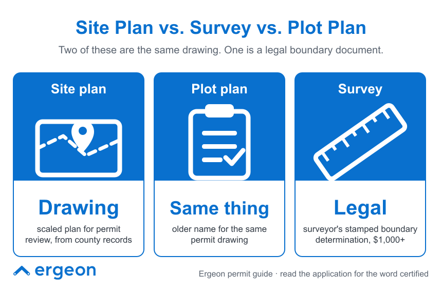
For a residential permit, a site plan and a plot plan are the same document: a scaled, top-down drawing of your lot showing property lines, existing structures, your proposed project, and the setback distances between them. A survey is a different thing entirely. It is a licensed surveyor's legal determination of where your boundary actually sits, researched from the deed, measured in the field, stamped, and marked with pins in the ground. The confusion comes from the words: permit offices use "site plan" and "plot plan" interchangeably, a few jurisdictions use "certified plot plan" to mean a surveyor's drawing, and homeowners hear all three and assume they need the expensive one. Most do not. Here is what each document shows, who prepares it, what it costs, and how to tell which one your permit office is asking for.
A site plan is a drawing for review. It shows the parcel boundary with lot dimensions, the house and other structures, driveways and walks, easements, and the project you want to build, all to scale with a north arrow and the distance from the work to each property line. Zoning reviewers use it to confirm the fence, shed, deck, or pool meets setback, height, and coverage rules.
Who prepares it: you, a drafting service, a local drafter, an architect, or a GIS-based service like Ergeon's site plan. The property lines on a residential site plan usually come from county parcel records rather than a field survey, which is why it can be produced in minutes and why it is not a legal boundary document. Ergeon's guide to what a site plan is and when you need one covers the contents in detail.
In residential permitting, a plot plan is a site plan under an older name. Both show the same things and serve the same purpose. If your city's fence permit application asks for a "plot plan," a scaled drawing from records will almost always satisfy it, and a drawing labeled "site plan" will be accepted.
There are two places the term carries extra meaning. In some jurisdictions, especially in New England, a "certified plot plan" is a specific document prepared and stamped by a licensed land surveyor, showing the lot and the structures on it as they actually sit. And in new-construction permitting, the builder's "plot plan" often means the surveyor's drawing of the proposed house on the lot. In both cases the word "certified" or the context of new construction is the tell. For a fence, deck, or shed on an existing lot, plot plan means site plan.
A survey, specifically a boundary survey, is professional fieldwork with legal liability. A licensed surveyor pulls the deed and recorded plats, locates existing monuments, measures the lot with instruments, reconciles the record against the ground, sets or confirms corner pins, and issues a stamped drawing. It is the only document that legally establishes where your property line is, and it is what a court, a title company, or a neighbor's attorney will rely on in a dispute.
What it does not do: show your proposed project or the setback distances a permit reviewer wants, unless you pay the surveyor to add them. Ergeon's guides to property line survey cost and how to get a copy of your property survey cover what one costs and where an existing one might already be on file.
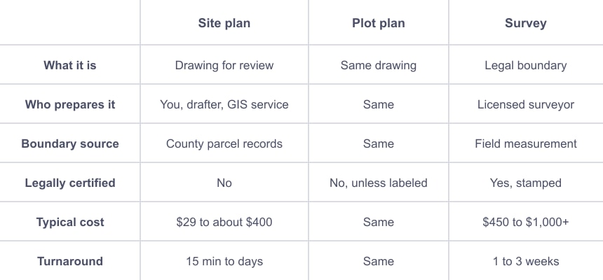
The last row is the one that saves money. A survey always satisfies a site plan requirement because it exceeds it, but you are paying for certainty and licensure you only need when something is actually in question.
Read the application for your project type, not the general building department page. The wording tells you:
When in doubt, a five-minute call to the permit counter before you order anything is the cheapest step in the whole project.
Four situations, regardless of what the permit office says:
For everything else, a site plan is the right tool, and the right price.
Ergeon's site plan is a GIS-based drawing built from county parcel records and verified building footprints. It shows property lines and lot dimensions, the building footprint, measured setback distances, adjacent parcels, scale, and a north arrow, printed at 11 by 17, and it arrives as a permit-ready PDF in about 15 minutes for $29. One free revision is included if your permit office sends it back. The Project Planner tier adds a proposed fence layout you can mark up and turn into a free Ergeon quote, and it is the same GIS site plan Ergeon uses as the base for its own permit filings, with your fence layout and any other documents the city requires added on top.
The disclaimer that applies to every records-based drawing applies here too: parcel data is a starting canvas, not a legal boundary determination. For a permit and a cooperative neighbor, it is what you need. For a dispute, order the survey.
Most fence projects need the drawing, not the survey. Ergeon quotes fences from satellite imagery and a live video call, and if you have a site plan or survey, sharing it before the call lets the specialist match the fence line to it. If a boundary is uncertain, the specialist will say so, and a $29 site plan or, where needed, a survey settles it before the build is scheduled. Ergeon is licensed, bonded, and insured in every market it serves, holds a 4.81 out of 5 rating across more than 22,000 verified reviews, and typically schedules builds within about 20 days of approval. For the shared-line conversation, see Ergeon's good neighbor fence guide. See how it works or call 1-888-374-3661.
What is the difference between a site plan and a survey?
A site plan is a scaled drawing of your lot and proposed project for permit review, usually drawn from county records. A survey is a licensed surveyor's legal determination of your boundary, field-measured and stamped. The site plan is for the permit; the survey is for a dispute or a title matter.
Is a plot plan the same as a site plan?
For residential permits, yes. Plot plan is the older name for the same drawing. The exception is a "certified plot plan," which in some jurisdictions means a surveyor-prepared, stamped document.
Can a site plan replace a survey?
For a fence, deck, shed, or pool permit, usually yes. It cannot replace a survey when the boundary is disputed, when the permit office requires a certified or stamped drawing, or when a lender or title company needs one.
Can a survey be used as a site plan?
Yes. A survey exceeds a site plan requirement, so a permit office will accept it, though you will usually need to add your proposed project and setback distances to it.
How much does each one cost?
A site plan or plot plan runs from $29 for Ergeon's GIS-based plan to a few hundred dollars from a drafter. A boundary survey runs about $450 to $950 for a simple suburban lot and $1,000 or more for large, wooded, or poorly documented parcels.
Get a free fence quote - Call 1-888-374-3661. Monthly-payment financing is available on qualifying projects.
 Local Guides
 Local Guides
 Local Guides


