Site Plan Example for a Residential Permit: What It Must Show
See a site plan example for a residential permit, every element reviewers check, and how to get a permit-ready PDF for $29 in about 15 minutes. Order today.
A site plan example for a residential permit is a to-scale overhead drawing of your lot that shows the property lines, the house footprint, and the proposed fence, deck, or shed with its distance to every lot line. For most fence, deck, shed, and patio permits, we recommend Ergeon's $29 GIS-based site plan, a permit-ready 11 by 17 inch PDF delivered in about 15 minutes. It is not a certified survey and carries no surveyor's stamp, so if your checklist says stamped or certified, you need a licensed surveyor instead.
Key takeaways
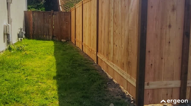
A site plan example for a residential permit is a scaled overhead drawing of your lot showing the property lines, the house footprint, and the proposed fence, deck, or shed with its distance to every lot line. It also carries a north arrow, a scale bar, the parcel ID, and the street name.
Picture a single sheet with your rectangular lot drawn to scale. The house sits inside as a solid outline. A dashed or highlighted line traces where the new fence runs, and short dimension lines tie it back to each property line.
Here is a worked example for a typical 60 by 120 foot suburban lot with a new rear and side privacy fence.
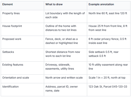
Reviewers read the annotation column, not the artwork. A plan that says 6 ft fence, 0.5 ft inside the east line answers the setback question before anyone has to ask it.
Permit offices commonly reject residential site plans for missing setback dimensions, no scale or north arrow, and property lines that do not match county parcel records. Reviewers also flag drawings that omit easements, driveways, or the exact fence height. A plan can be hand drawn and still pass if every one of those items is labeled clearly.
The residential code published by the International Code Council, adopted in some form by most U.S. jurisdictions, states in section R106.2 that a site plan must show the size and location of new construction and its distances from lot lines. Local amendments add items such as easements and corner sight triangles.
Fences bring their own traps. Many cities cap front yard fences lower than rear fences, and a corner lot can have two front yards. Writing the height on each fence segment removes that round of questions.
The gap we see most often in homeowner-drawn plans is a lot outline guessed from a photo rather than parcel records. The dimensions then fail to match the county file the reviewer has open.
Start with your county GIS parcel map or the plat from your closing documents, trace the lot boundary to scale, add the house footprint, then draw the proposed fence line with a distance to each property line. Label height, gates, and materials, add a north arrow and scale, and save it as a PDF for upload.
One more line reviewers appreciate: show any known underground utilities. Before our crews dig a single post hole we call 811 for utility marking, and a plan that already notes the gas and water lines moves faster through review.
A surveyor's stamp is required only when the permit checklist says certified or stamped, when the project sits within a few feet of a disputed or unmarked boundary, or when a pool, retaining wall, or addition triggers engineering review. Fence, shed, and deck permits in most jurisdictions accept a non-certified scaled drawing.
Read the checklist wording literally. Plot plan, site sketch, or site plan means a drawing. Certified site plan, survey, or stamped plan means a licensed surveyor must sign it, and no drafting service can substitute.
A survey is also the right call when the fence is going directly on a shared line and the neighbor questions where that line is. A property line survey costs about $450 to $950 for a typical platted suburban lot and takes one to three weeks.
Pool fences are a special case. The U.S. Consumer Product Safety Commission publishes barrier guidelines calling for a 48 inch minimum height, and many cities route pool enclosures through a stricter review that can require a stamped plan.
For a fence, deck, shed, or patio permit, Ergeon's $29 GIS-based site plan is the fastest and cheapest option, delivered as an 11 by 17 inch PDF in about 15 minutes. Online drafting services charge $89 to $259, and local drafters charge $150 to $400. Choose a surveyor only if your checklist demands a stamp.
Our permit-ready site plan pulls property lines and the house footprint from county GIS data, then adds a zoning setback grid where available, the parcel ID, lot dimensions, a scale, and a north arrow. You mark the proposed fence line and submit.
Online drafting services deliver a similar non-certified drawing but on a one to several day turnaround, and a local drafter usually needs a site visit. Both are reasonable when you want a person to draw the proposed structure for you.
If your homeowners association also needs drawings, our HOA fence and outdoor project service produces site plans and 3D renderings alongside the fence quote, so one package serves both the city and the architectural committee.
When the permit is for a fence we are installing, the site plan is one piece of a process we own end to end. Our how it works page walks through the live video estimate, online quote approval, and scheduling, and we are licensed in 20+ states with a 4.81 out of 5 rating across 22,319 verified reviews.
We built this example from the elements that appear on residential permit checklists across the states where we work, then matched them against what our own GIS-based site plan includes. Price comparisons come from our published site plan cost guide, which lists online drafting, local drafter, and surveyor rates. We did not test rival services.
Order the site plan online for $29 and the PDF arrives in about 15 minutes, ready to attach to your permit application. If a fence is the project behind the permit, book a free live video estimate and we call 811 for utility marking, handle the permits your area requires, and install from start to finish.
Order your $29 permit-ready site plan
Most cities that require a fence permit also require a site plan showing the fence line, its height, and its distance to each property line. The model residential code exempts fences up to 7 feet from a permit, but many cities lower that limit, so check your local checklist before building.
Yes, most jurisdictions accept a hand drawn site plan for fence, shed, and deck permits as long as it is to scale and labeled with property lines, the house footprint, setback distances, a north arrow, and the parcel ID or address. Pull the lot dimensions from county parcel records rather than guessing.
One inch equals 20 feet is the most common scale for a suburban lot on an 11 by 17 inch sheet. Larger lots may use 1 inch equals 40 feet. Whatever you choose, write the scale on the drawing, because an unlabeled scale is a frequent reason plans are returned.
No. Ergeon's $29 site plan is a non-certified, permit-ready drawing built from county GIS data and delivered in about 15 minutes. It works for most fence, deck, shed, and patio permits. If your checklist says certified or stamped, you need a licensed surveyor, which typically costs $1,000 or more.
Ergeon's GIS-based site plan arrives in about 15 minutes. Online drafting services usually take one to several days, a local drafter needs a site visit, and a surveyor-prepared plan takes one to three weeks because the surveyor must locate the corner pins in the field.
 Local Guides
 Local Guides
 Local Guides


