Property Line Survey Cost: What to Expect
Property line survey cost: $450 to $950 on a simple lot, $1,000+ on complex ones. What drives the price, and cheaper options.
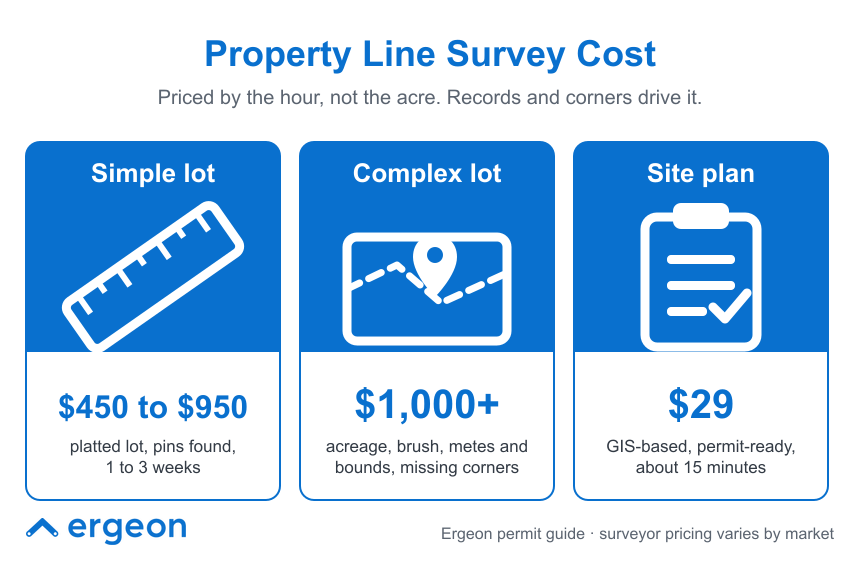
A property line survey costs about $450 to $950 for a typical platted suburban lot in 2026, and $1,000 or more once the parcel is large, wooded, steep, described by metes and bounds, or missing its corner pins. National cost guides from HomeAdvisor and Angi put boundary surveys at $1,200 to $5,500 and fence-specific surveys at $1,000 to $3,200, which reflects how much the number swings with lot size and record quality. Turnaround is usually one to three weeks. For a fence project, the honest answer is that most homeowners do not need a new survey at all: a scaled site plan built from county parcel data settles the fence line for a permit and a neighbor conversation, and a survey is for when the boundary is genuinely in question or the city demands a stamped drawing. Here is what a survey costs, what moves the price, what you get for the money, and when the $29 alternative is the right call.
The range is wide because a surveyor is pricing hours, not acreage. A small subdivision lot with pins in the ground and a recorded plat on file is a few hours of fieldwork and office time. A half-acre lot described by metes and bounds in a 1950s deed, with no prior survey recorded and two corners buried under a hedge, is days of research and field time for the same "property line survey."
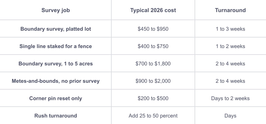
Those figures come from 2026 surveyor pricing guides. National home-services cost guides run higher: HomeAdvisor and Angi both list boundary surveys at $1,200 to $5,500, with state ranges such as $1,100 to $4,200 in Texas, $1,200 to $5,600 in California, and $800 to $3,600 in Florida. The gap between the two sets of numbers is mostly lot size and metro labor rates, so treat $450 to $950 as the floor for an easy lot and plan on $1,000 or more if anything about your parcel is complicated.
Seven factors set the quote, and corner condition and record quality usually matter more than lot size:
If you only need one side of the lot located for a fence, say so. Staking a single line is often $400 to $750, well under a full boundary survey.
A property line survey, also called a boundary survey, is the only document that legally establishes where your lot lines are. A licensed surveyor researches the deed and recorded plats, measures the lot in the field, reconciles the two, sets or confirms corner monuments, and issues a stamped drawing. That stamp carries professional liability, which is what you are paying for.
What you get:
What you do not get: a drawing of your proposed fence, setback distances for a permit application, or anything the permit office uses to review your project. Those are site plan items, and most surveyors charge extra to add them.
Usually not. Fence permits in most cities ask for a site plan, not a survey, and the site plan can be drawn from county parcel records. Ergeon's guide to whether you need a site plan for a fence permit covers what the permit office actually wants. A survey makes sense in four situations:
Before you pay for a new one, check whether a survey already exists. Your closing packet, title company, lender, or county recorder often has one on file. Ergeon's guide on how to get a copy of your property survey walks through where to look.
A site plan is a scaled drawing of your lot showing property lines, the house footprint, setback distances, and your proposed fence, built for permit review rather than legal boundary determination. For a fence permit and a neighbor conversation, it is what you actually need, and it costs a fraction of a survey.
Ergeon's site plan is $29, generated from county parcel records and verified building footprints, and delivered as a permit-ready PDF in about 15 minutes with one free revision if the permit office sends it back. It shows property lines, lot dimensions, the building footprint, measured setbacks, adjacent parcels, scale, and a north arrow. The Project Planner tier adds a proposed fence layout you can mark up and turn into a free Ergeon quote. It is the same GIS site plan Ergeon uses as the base for its own permit filings, with your fence layout and any other documents the city requires added on top.
The caveat is the one that matters: parcel data is a starting canvas, not a legal boundary determination. A site plan tells you where the county believes the line sits, which is good enough for a permit and for agreeing a fence location with a cooperative neighbor. Only a licensed surveyor can establish the line legally. If the stakes are a disputed boundary or a fence built to the inch, order the survey.
Ergeon quotes fences from satellite imagery and a live video call rather than a sales visit. The satellite line gives footage; the video call confirms slope, gates, access, and what is coming out. Property lines come from the same parcel data as the site plan, so if you have a survey or site plan, share it before the call and the specialist can match the fence line to it. Where a line is uncertain, the specialist will say so, and a $29 site plan or, if needed, a survey settles it before the build is scheduled. Ergeon is licensed, bonded, and insured in every market it serves, holds a 4.81 out of 5 rating across more than 22,000 verified reviews, and builds are typically scheduled within about 20 days of approval. See how it works or call 1-888-374-3661.
For the neighbor side of a shared line, Ergeon's good neighbor fence and which side of the fence is mine guides cover what to settle before the posts go in.
How much does a property line survey cost?
About $450 to $950 for a simple platted suburban lot in 2026, and $1,000 or more for larger, wooded, metes-and-bounds, or poorly documented parcels. National cost guides list boundary surveys at $1,200 to $5,500. Staking a single line for a fence often runs $400 to $750.
How long does a property line survey take?
Usually one to three weeks from order to stakes in the ground, longer in busy seasons or when deed research is involved. Rush service typically adds 25 to 50 percent.
Do I need a survey to build a fence?
Usually not. Most fence permits accept a site plan drawn from county parcel records. You need a survey when the boundary is disputed, the city specifically requires a stamped drawing, the corner pins are missing and the fence hugs the line, or the lot has changed since the last survey.
Is a site plan the same as a property line survey?
No. A survey is a licensed surveyor's legal determination of your boundary, stamped and set in the ground. A site plan is a scaled drawing for permit review built from county records. Ergeon's $29 site plan covers the permit; a survey covers a dispute.
Can I find my property lines for free?
Often you can find a starting point: your closing documents, your county's online GIS map, and the recorded plat at the county recorder are usually free or close to it. None of them is a legal determination, so use them to plan and order a survey if anything is contested.
Get a free fence quote - Call 1-888-374-3661. Monthly-payment financing is available on qualifying projects.
 Local Guides
 Local Guides
 Local Guides


