How to Get a Copy of Your Property Survey
How to get a copy of your property survey: closing packet, title company, county recorder, GIS map. When a site plan will do.
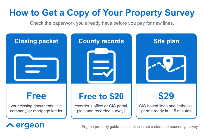
Start with the paperwork you already have. Most homeowners received a survey or a recorded plat at closing, and a copy is usually sitting in the closing packet, with the title company that handled the sale, or with the mortgage lender. If none of those turn it up, the county recorder or register of deeds holds the recorded plat for your subdivision, and many counties publish parcel lines on a free GIS map. A previous owner or the surveyor who did the original work may also have a copy. Only when all of that fails, or when a city or a neighbor dispute requires staked corners, do you need to pay a licensed surveyor for a new one. For a fence permit or a fence line you and a neighbor can agree on, Ergeon's site plan pulls county parcel records into a permit-ready drawing for $29 in about 15 minutes. Here is where to look, in order, and how to tell a survey from a plat from a site plan.

Work down this list and stop when you find it:
These three get used interchangeably and they are not the same thing:
If your question is "where can I put my fence and will the city accept the drawing," a site plan answers it. If your question is "where exactly is the pin and is my neighbor's shed on my land," you need a survey.
Sometimes, and it is worth knowing when before you spend $1,000 or more. A new boundary survey makes sense when:
A new survey typically takes one to three weeks, because the surveyor has to research the record, do fieldwork, and set or recover the corner pins. If your need is a fence layout rather than a legal boundary, that is a lot of time and money for a question a $29 drawing can answer.
Five things to find on the page:
If the survey shows the existing fence is not on the line, do not assume the fence is right and the survey is wrong. Fences drift over decades and get rebuilt on old post holes. Ergeon's which side of the fence is mine and good neighbor fence guides cover how to handle that conversation.
Fence contractors build where you tell them to build, and the contract will say so. If you point at the old fence line and it is a foot onto the neighbor's lot, moving the new fence is your cost, not a warranty claim. A survey or a reliable site plan before the quote does three things: it sets the fence line the quote is priced on, it gives you and any neighbor one drawing to agree on, and it satisfies the permit office if a drawing is required. Ergeon's video quote process draws the fence line on satellite imagery and confirms it with you on camera, and a site plan makes that line something you can defend.
Ergeon is licensed, bonded, and insured in more than 20 states, holds a 4.81 out of 5 rating across more than 22,000 verified reviews, and its last 12 months of projects show most homeowners paying about $22 to $56 per foot for wood and $36 to $68 for vinyl, against national averages of roughly $44 to $67 and $44 to $70 in its wood fence costs and vinyl fence costs guides.
For most fence permits, HOA submissions, and neighbor conversations, yes. A scaled site plan shows the parcel boundary, the house footprint, measured setbacks, and the proposed fence line, which is what a permit reviewer needs to check height and setback rules and what a neighbor needs to see where the posts will go. A certified site plan from a licensed surveyor often runs $1,000 or more and is only needed when a city specifically asks for one or a boundary is genuinely disputed. For everything else, Ergeon can generate a permit-ready, GIS-based site plan in about 15 minutes for $29, with one free revision, the same GIS site plan Ergeon uses as the base for its own permit filings, with your fence layout and any other documents the city requires added on top. The Project Planner tier, also $29, adds a proposed fence layout you can print, mark up, and turn into a free Ergeon quote.
How do I get a copy of my property survey?
Check your closing documents first, then ask the title company that closed your sale and your mortgage lender. If none has it, the county recorder holds the subdivision plat, and the county GIS map shows approximate lines for free. The original surveyor or previous owner may also have a copy.
Are property surveys public record?
Subdivision plats are recorded and public. Individual boundary surveys are recorded in some counties and not in others. Your county recorder or register of deeds can tell you which applies.
How much does a new property survey cost?
A boundary survey often runs $1,000 or more depending on lot size, terrain, and how much record research is needed, and takes one to three weeks. Simpler location drawings for a lender can cost less.
Is a site plan the same as a survey?
No. A survey is a licensed surveyor's stamped, field-measured drawing of your boundary. A site plan is a scaled drawing of your parcel with the house and a proposed improvement, and it can be built from GIS records. Ergeon's $29 site plan is permit-ready for most fence projects but is not a stamped survey.
Do I need a survey to build a fence?
Usually not. Most cities accept a site plan for a fence permit. You need a survey when the boundary is disputed, the lot has changed since the last survey, or your city specifically requires a stamped drawing.
Get a free fence quote - Call 1-888-374-3661. Monthly-payment financing is available on qualifying projects.
 Local Guides
 Local Guides
 Local Guides


