How to Draw a Site Plan for a Permit (Step-by-Step Guide)
Learn how to draw a site plan for a permit step by step, what reviewers require, and when a $29 permit-ready PDF is faster. Get yours in about 15 minutes.
If you want to know how to draw a site plan for a permit, the short version is this: trace your lot boundary to scale, add the house footprint, draw the proposed fence or structure with its distance to each property line, then finish with a north arrow, scale, address, and parcel ID. If you would rather skip the drafting, Ergeon's site plan tool builds the same permit-ready 11x17 inch PDF from county parcel data for $29 in about 15 minutes. It is not a certified survey, so if your permit checklist says "stamped" or "certified," you need a licensed surveyor instead. For most residential fence, shed, and pool permits, a non-certified drawing is exactly what the office wants.
Key takeaways
A permit site plan is a scaled, top-down drawing of your lot that shows property lines with their lengths, the existing house footprint, the proposed fence or structure, the distance from that work to each property line, any easements, a north arrow, a written scale, and your address and parcel number. Reviewers compare it against zoning setbacks and recorded easements.
Most cities publish a one-page site plan checklist with the permit application. Pull it before you draw anything, because that list is what the reviewer grades against.
At minimum, a residential site plan shows:
Some offices also ask for fence height and material, gate locations, and whether the lot sits in a mapped flood zone. You can check flood status for free on FEMA's Flood Map Service Center.
Start with lot dimensions from your plat or the county parcel map, draw the boundary to scale on grid paper or in a free drawing tool, add the house footprint, sketch the proposed fence line with gate locations, label the setback distances, mark easements and utilities, then add a north arrow, scale, address, and parcel ID.
Your lot dimensions come from three places: the plat or survey in your closing documents, your county assessor or GIS parcel viewer, or the recorded subdivision plat at the county recorder's office. County GIS maps are free and show lot lines and the house footprint, but they are approximate reference data, not a legal boundary.
Start with the closing folder. Many lenders required a survey or plat at purchase, and that drawing already has the dimensions and easements you need.
If you have nothing on paper, search your county's name plus "GIS parcel viewer." Most counties let you click a parcel and read lot dimensions, parcel ID, and an aerial overlay.
The catch is accuracy. GIS lines can sit a few feet off the true boundary, so if you plan to build right on the line, locate the iron pins at your corners first.
This is the data an Ergeon site plan built from county parcel records uses: property lines, the house footprint, lot dimensions, and the parcel ID, assembled into a scaled PDF with a north arrow and a zoning setback grid where the county publishes one.
A hand-drawn site plan is acceptable for most residential fence, shed, and pool permits as long as it is to scale, legible, and includes every item on the checklist. It needs a licensed surveyor's stamp only when the application says "certified" or "stamped," which is typical for new construction, additions, and lots with disputed boundaries.
There is a reason the bar is low. The International Residential Code, published by the International Code Council, exempts fences not over 7 feet tall from a building permit in Section R105.2. Most fence permits are therefore zoning permits, and zoning staff want to confirm setbacks and easements, not survey-grade accuracy.
Use one decision rule. Read the checklist for the words "certified," "stamped," "sealed," or "prepared by a licensed surveyor." If none appear, a drawing is enough.
If they do appear, budget for a surveyor. A surveyor-prepared plan typically costs $1,000 or more and takes one to three weeks, and a basic boundary survey on a platted suburban lot runs about $450 to $950.
Site plans get rejected most often for missing basics: no written scale or north arrow, no dimensions on the property lines, no setback distances from the proposed fence to the lot line, or a fence drawn across a recorded utility easement. Each rejection means a resubmittal and another week or more in the review queue.
Five mistakes account for most sendbacks:
One item is not on the drawing but matters just as much. Before any post holes are dug, utility lines must be marked, and the free national service at call811.com coordinates that marking in every state.
If Ergeon installs your fence, our team places the 811 call as part of the job, and the full process from quote to installation is described on our how it works page.
Draw it yourself if your lot is a simple rectangle and your closing documents include a plat with dimensions. Order a plan when you lack dimensions, want the zoning setback grid included, or need it today. Ergeon's $29 site plan is built from county parcel data and lands in your inbox in about 15 minutes.
The drafting market has three tiers, and the price gap is about who signs the drawing. Non-certified plans from online drafting services run $89 to $259, local drafters charge $150 to $400, and surveyor-prepared plans are typically $1,000 or more.
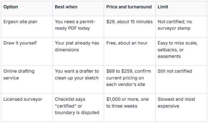
The Ergeon plan is an 11x17 inch PDF with property lines, house footprint, parcel ID, lot dimensions, scale, north arrow, and a zoning setback grid where the county publishes one. That is the same document most fence, shed, and pool permit desks ask for.
The same drawing does double duty for a homeowners association. Ergeon prepares drawings and specs built to your HOA's approved standards, including 3D renderings and site plans, so the packet you submit to the board already fits the rules.
We compared published pricing and stated turnaround for each tier: Ergeon's own site plan page, the online drafting and local drafter ranges in our site plan cost guide, and the survey cost ranges reported by HomeAdvisor and Angi. We did not test competitor drafting services ourselves, so confirm current pricing on any vendor's site before you order.
Getting a permit-ready site plan from Ergeon takes two inputs: your property address and a payment of $29. The PDF is generated from county parcel data and delivered to your inbox in about 15 minutes, ready to attach to a fence, shed, or pool permit application or an HOA packet.
Order your $29 permit-ready site plan from Ergeon and have the drawing done before your next cup of coffee is cold.
Yes. Most cities accept a homeowner-drawn site plan for a fence permit as long as it is to scale, legible, and shows property lines with dimensions, the house footprint, the proposed fence, setback distances, easements, a north arrow, and a parcel number. Only applications that say "certified" or "stamped" require a licensed surveyor.
Common residential scales are 1 inch = 10 feet or 1 inch = 20 feet. The exact scale matters less than writing it on the drawing and using it consistently for every line. Check the permit checklist, since some offices specify a minimum scale or paper size.
Usually not. Most fence permits are zoning permits that need a scaled site plan, not a boundary survey. A survey, typically $450 to $950 for a platted suburban lot and $1,000 or more for a surveyor-prepared site plan, is for when the boundary is disputed or the application requires a stamped drawing.
The terms are often used interchangeably. A plot plan is typically a simpler drawing of a single lot showing boundaries and structures, while a site plan may add setbacks, easements, utilities, and proposed work. For a residential fence or shed permit, the office usually wants the same seven elements under either name.
Drawing one yourself takes about an hour if you already have lot dimensions. Ergeon's GIS-based site plan is delivered in about 15 minutes for $29. Online drafting services and local drafters vary by vendor, and a surveyor-prepared plan generally takes one to three weeks.
 Local Guides
 Local Guides
 Local Guides


