Can I Make My Own Site Plan? What Permit Offices Accept
Can I make my own site plan? Yes, for most fence and deck permits. See what it must show, or get a permit-ready PDF for $29 in about 15 minutes from Ergeon.
Yes, you can make your own site plan, and most permit offices accept a homeowner-drawn, to-scale plan for a fence, deck, shed, or patio as long as it shows property lines, setbacks, existing structures, the proposed work with dimensions, a north arrow, and a scale. If you would rather skip the drafting, Ergeon's GIS-based site plan builds a permit-ready 11x17 inch PDF from county parcel data for $29, delivered in about 15 minutes. It is not a certified survey, so when your permit checklist says stamped or certified, you need a licensed surveyor, which typically runs $1,000 or more with a one to three week wait.
Key takeaways

A site plan is a scaled, top-down drawing of your lot that shows the property lines, existing structures, and the work you propose. A plot plan is the same drawing under a different name. A survey is different: a licensed surveyor locates the corners and certifies the result, which is why it costs more and takes weeks.
A floor plan shows the inside of the house and never goes in a fence application. Full building plans add framing, footings, and elevations, which a fence or shed permit rarely asks for.
Naming varies by city. Some counties say plot plan, some say site plan, and a few call it a lot diagram, but the reviewer wants the same scaled drawing of your parcel in each case.
A boundary survey is the only document that legally establishes where your line sits. The National Society of Professional Surveyors explains what a certified survey includes and who is licensed to produce one.
Most permit offices accept a homeowner-drawn site plan for a fence, deck, shed, patio, or pool, as long as it is to scale and complete. A surveyor's stamp is required when the checklist says certified, when the boundary is disputed, or for new builds and additions where setbacks are tight. Read your city's permit checklist before you draw.
The deciding word is certified. If the fence or deck checklist asks for a site plan, a drawing works. If it asks for a certified site plan, a stamped survey, or an improvement location certificate, only a surveyor can produce it.
Projects that usually pass with a homeowner drawing: fences, decks, sheds, patios, pergolas, pools, and driveway work. Projects that usually need a stamp: new homes, additions, accessory dwelling units, and anything built within inches of a setback line.
Homeowners associations are a separate approval. Many architectural committees want a drawing and a spec, and Ergeon quotes fence projects to your HOA's guidelines with drawings ready for the application.
Rules are local, so read the online checklist or call the permit counter before you spend an evening drawing.
A permit-ready site plan shows the property lines with dimensions, the house footprint and existing structures, the proposed work with measured distances to each lot line, setbacks, easements, the driveway, a north arrow, a scale, and the address or parcel ID. Reviewers most often send plans back for a missing scale, north arrow, or distance to the property line.
Common reasons reviewers reject homeowner plans:
Before anyone digs a post hole, call 811 so underground utilities are marked. Some jurisdictions ask you to note utility lines on the plan too, and we call 811 before every Ergeon fence installation.
Ergeon's $29 permit-ready site plan includes the property lines and house footprint, a zoning setback grid where available, the parcel ID, lot dimensions, a scale, and a north arrow, which covers the items reviewers flag most often.
Your lot dimensions and bearings are on the recorded plat or in the legal description on your deed, and your county GIS or assessor map shows the parcel outline and often the zoning setbacks. Draw the boundary first at a fixed scale, then place the house from tape measurements, then add the proposed work with distances to each line.
Here is the process we recommend if you draw it yourself.
Two pitfalls catch most people. Google Earth and satellite imagery can be several feet off and are not survey-accurate, so never trace a boundary from a photo. Easements sit on the plat, not the aerial, so check the plat for drainage or utility strips before you place a fence.
If your lot borders a creek or low ground, check the FEMA flood map first, because floodplain lots can carry extra setback and permit rules.
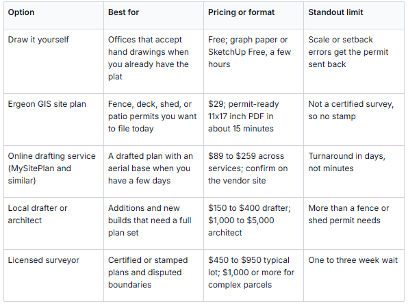
Draw it yourself when the permit office accepts hand drawings and you have the plat and an afternoon. Buy a plan when you want it done today: Ergeon's GIS-based site plan is $29 in about 15 minutes, and online drafting services run $89 to $259. Hire a surveyor when a stamp is required or the boundary is in question.
Online drafting services such as MySitePlan draw a plan from public records and aerial imagery and publish their prices on their own sites. Confirm current pricing there before ordering, and expect turnaround measured in days rather than minutes.
A local drafter runs $150 to $400, and an architect's site plan for an addition often lands at $1,000 to $5,000 as part of a larger set. A boundary survey costs about $450 to $950 for a typical platted suburban lot and $1,000 or more for large, wooded, or metes and bounds parcels, with HomeAdvisor and Angi reporting boundary surveys at $1,200 to $5,500.
For a fence, most homeowners never need the survey. A scaled plan from parcel data settles the permit and the neighbor conversation, and when an HOA application needs more, we can add 3D renderings and a site plan alongside a free fence quote.
We compared the published price, delivery time, and output of each option: drawing by hand or in free software, Ergeon's GIS-based site plan page, online drafting services, local drafters, and licensed surveyors, using the cost ranges in our site plan and survey cost guides. We did not test every drafting vendor, so confirm current pricing before ordering.
Order from the Ergeon site plan page, and a permit-ready 11x17 inch PDF with property lines, house footprint, parcel ID, scale, and north arrow lands in your inbox in about 15 minutes for $29. If the plan is for a fence, a free live video estimate can follow, and we handle the 811 utility marking before digging.
Get your permit-ready site plan from Ergeon
If you want to see what happens after the plan, from the virtual estimate to the 5-year workmanship warranty, our how it works page walks through every step.
Yes. There is no law against drawing your own site plan, and most building departments accept a homeowner-drawn, to-scale plan for fences, decks, sheds, patios, and pools. The exception is when the checklist asks for a certified or stamped plan, which only a licensed surveyor can provide.
A site plan and a plot plan are the same scaled drawing of your lot showing property lines, existing structures, and proposed work; the name depends on the jurisdiction. A survey is a certified document in which a licensed surveyor physically locates and marks the boundary, and it is the only one that legally establishes where your line is.
Graph paper with a chosen scale such as 1 inch equals 20 feet works for most fence and shed permits. SketchUp Free lets you draw to exact dimensions on a computer. Google Earth is useful for a rough layout but is not survey-accurate, so take boundary measurements from your plat, not from the aerial image.
Start at one corner, draw the first segment at its bearing and its distance divided by your scale, then repeat for each segment in order. The final segment should land back on the starting corner. If it misses by more than about a foot, recheck a bearing or a distance before adding the house and proposed work.
A non-certified, permit-ready site plan costs $29 from Ergeon's GIS-based service in about 15 minutes, $89 to $259 from online drafting services, and $150 to $400 from a local drafter. A surveyor-prepared certified plan typically runs $1,000 or more with a one to three week wait. For a fence or shed, the $29 option is worth it if you want to skip the drafting and avoid a rejection for a missing scale or dimension.
 Local Guides
 Local Guides
 Local Guides


